Creating a Bridge Between Engineering and Water Policy; A Summary of My MSc Thesis
- Sina Masoumzadeh
- Aug 8, 2021
- 4 min read

Updated: Aug 13, 2021
Numerous stakeholders, various domains, multiple scales, uneven spatiotemporal distribution, and the absolute necessity of water for sustaining life on the planet Earth; there is no need for extensive explanation just by glancing at the mentioned qualities about the water resources management problems, it becomes clear that attempting to solve these problems will not result in a robust and sustainable solution requires an in-depth study and elaborate planning. The complexity can quickly grow and aggravate the situation when we are taking transboundary rivers into consideration. Since water does not respect the political boarders, international and intranational transboundary rivers are encountered abundantly and about 40% of the world’s population lives in 286 transboundary river basins.

Being 1150 km long, the Helmand River is one of the two transboundary rivers located at the southern boundary of Iran. Shared mainly between Iran and Afghanistan (a small fraction of the watershed is located in Pakistan) this river provides the main water for Afghan and Iranian farmers. The biodiversity of the region also depends heavily on this river and the Hamun Wetlands which span parts of Iran and Afghanistan and is recognized internationally under the Ramsar Convention also relies on this river to sustain themselves. As crucial as this river is for the region, it always was a conflict ground between Iran and Afghanistan and the negotiation on its water has a long anecdote as it was started in 1870. In 1973, the Helmand River Water Treaty was signed between the two countries that allotted 22 m3/sec plus a 4 m3/sec at normal water years. However, this treaty was never fully implemented and the ambiguity of it has been always criticized by researchers. Till present day attempts have been made to renew the negotiation but all in vain.

Afghans believe Iran has been taking advantage of the conflicts and war within the country to take more water using pumps and artificial lakes and now Iranian officials claim that even when floods occur the Afghans do not provide Iran with even a fraction of the agreed amount. The situation requires a study with scrutiny to be conducted on the matter. The first thing to analyze such a problem is to measure and calculate the potential water resources in the region. Here appears the first obstacle. There is little or no data available since there is no cooperation between countries on the matter. Hence, in my thesis, I tried to alleviate this problem using remote sensing techniques and since the Helmand River’s water is provided by the snow on the Hindu Kush Mountains MODIS snow products were utilized to assess whether there was a statistically decline in precipitation that caused the current drought in the Hamun Wetlands, are we dealing with a mainly anthropogenic cause for this situation or maybe a collection of reasons are responsible for the current situation of the Hamun Wetlands which is (or better to say “was”) home to diverse wildlife and was a pillar of the fragile economy of the Sistan and Balouchestan Province. Afterwards, based on the derived results, solutions to restore the basin have been proposed using knowledge synergy motivated by the win-win approach.

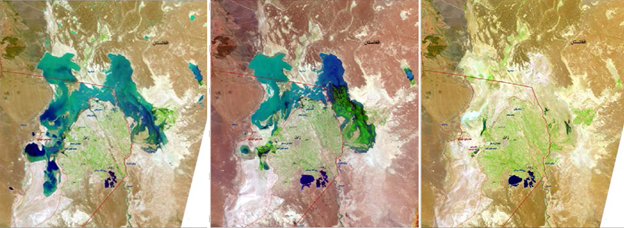
Remote sensing snow cover analysis of the basin showed that during the period 2000 till 2007, an increasing trend exists in the snow cover area of the basin, but after 2007, a decline is observable. In 2017, the snow cover area has been reduced by 48% compared to 2007. However, Mann-Kendall's non-parametric trend analysis at a 95% confidence level, showed, statistically, no meaningful trend is present in 2000 till 2017 period.


For further analysis of the state, 24 CFSR global synoptic stations data were analyzed from 2000 till 2014. The results showed that there is a positive increasing trend in the time series of precipitation in the basin, which was confirmed by the Mann-Kendall trend analysis method. It can be concluded that there is no meaningful decrease in the water input to the basin. However, there is a precipitation pattern change from snow to rainfall in recent years. So, the main reason for the decrease of the discharge in downstream Iran lies in anthropogenic changes in upstream Afghanistan. It is obvious that all aspects of the problem must be analyzed simultaneously to reach a reliable solution.
Thus, the situation of Helmand River was discussed at the panel held in the first Governance and Public Policy conference (Sharif University of Technology, December 2017), titled “A Reframing of Hirmand Water Conflict Problems: Good for Afghanistan Great for Iran”.

To give possible solutions and policies the discussed matters were synthesized and 10 possible solutions were presented. At the end of the session, a survey on the presented solutions was carried out among 50 experts with diverse backgrounds ranging from independent researchers, activists to local authorities. According to the survey, creating a free-trade zone, presenting transit services in return for water, and developing the tourism sector in the region were chosen as the top three solutions according to the experts. Since one of the main objectives of this thesis was to find a win-win solution, the top three mentioned solutions were analyzed using the benefit-sharing approach.
The final result was that alongside these solutions, a change of point of view on water from a stock to a flux, which requires development in the technology of water use in order to reuse the water as much as possible, desecuritization of data, and creating an organization under the supervision of organizations responsible for water at both Iran and Afghanistan will lead to a non-zero-sum solution and will increase the cooperation of the two stakeholder countries on the matter which will possibly lead to restoration of the Hamoun Lake.


Comments